FAQ
Frequently Asked Questions
RBR Roadbook Reader App
- How to scroll the roadbook?
- What is the "Autoscroll"?
- How to adjust/reset the odometer?
- Roadbook "countdown style"?
- Roadbook tulip/notes zoom (magnifier)
- How to lock screen roatation/touch?
- How to adjust the tripmeter?
- Speed limit zones, speeding
- What to do if lost (using go-to-note)?
- Miss or skip a waypoint
- Waypoints
- Auto-adjust Odometer
- Sounds
- About GPS: precise, fast, external?
- Using the RBR app offline
- Results or replay not showing up
- Device swapping during a ride
Riding roadbooks and GPX trails
Participate in the Event
Managing Tracks/Roadbooks
- How to create your first Digital Rally Roadbook?
- What should be considered when designing track/roadbook?
- STOP sign: special waypoint vs. traffic-sign drawing
- How do I add/upload a track (Roadbook or GPX trail)?
- Can I edit and re-upload a roadbook? Will results recalculate?
- How do I export a roadbook from Rally Navigator?
- How to share tracks?
- How does "Navigate by" work?
- Can I add waypoints to a GPX trail track?
- What is a Track/Roadbook PIN code?
- Access: Public, unlisted, private Track/roadbook visibility?
- Track structure errors
Organizing Events
- Can I use RBR as the event platform for my own rally business or club?
- How do I organize my first event?
- How do the payments and entry fees work?
- Event itinerary: classes, sections (tracks) explained
- Why can’t I change a competitor’s class after they’ve started riding?
- Can the same section behave differently for different classes?
- What is a Selective Section (SS)?
- What is a Rolling Start?
- How can competitors register for an event?
- How and when can competitors access event roadbooks?
- Can I decide during the event who is allowed to start the next section?
- Event Track "visibility" (access) explained
- How to test-ride event tracks and itinerary?
- Can a section be left out of the overall results?
- Nominal Time configuration
- What should be considered when choosing time zones for an event?
- Types of waypoints
- Auto-skipping missed waypoints
- Does the platform validate waypoints?
- What is a prologue?
- What is a Liaison or Road Section?
- Neutralization vs Transfer Zones (and refuelling)
- How to add a DN (neutralization zone)?
- How to set speed limits?
- Speeding penalties
- How do I set the DSS (section) start times?
- How do I record the start time as there will be no referee at the start?
- Start list live fullscreen mode
- Live Tracking
- Event "visibility" explained
- FIM & FIA regulations & Lexicon
How to ride and read the roadbook
Other
Can I add waypoints to a GPX trail track?
Updated
Yes - waypoints can be added to a GPX trail track.
Technically navigation by GPX trail in RoadbookRally works the same way as navigation by roadbook. The only difference is that instead of showing roadbook instructions, the RBR app displays the route line with waypoints on the map. The same rules apply as for a roadbook - DSS, ASS, speed zones, waypoint validation, etc. (see track/roadbook design guidelines).
This mode can be enabled by setting the "Navigate by" to GPX trail.
Technically navigation by GPX trail in RoadbookRally works the same way as navigation by roadbook. The only difference is that instead of showing roadbook instructions, the RBR app displays the route line with waypoints on the map. The same rules apply as for a roadbook - DSS, ASS, speed zones, waypoint validation, etc. (see track/roadbook design guidelines).
This mode can be enabled by setting the "Navigate by" to GPX trail.
Requirements for GPX navigation
- Simple GPX files contain only track points and are not valid for navigation.
- You have to add all needed waypoints (DSS, ASS, speed zones, etc.)
- The RoadbookRally.com system will automatically generate waypoints for you if no waypoints found in the uploaded GPX file.
- It is recommended to use use tools like Rally
Navigator, ridewithgps.com or gpx.studio to set
waypoints
for your GPX trace files.
You can mark hazards (danger exclamation marks) in the roadbook, and they will be visible on the GPX map for the riders, like this: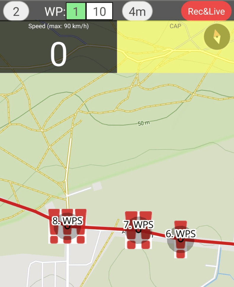 Drop us an email if you want RoadbookRally to add support for additional third
party GPX
management tool.
Drop us an email if you want RoadbookRally to add support for additional third
party GPX
management tool.
Workflow using RallyNavigator.com
- Create a standard roadbook first (with DSS, ASS, waypoints, speed zones, etc).
- Export it as an OpenRallyGPX
- Upload it to RoadbookRally and select Navigate this Track by → GPX trail.
- Verify that waypoints, DSS, ASS, and speed zones are visible on the GPX map.
How to add waypoints using gpx.studio or ridewithgps.com?
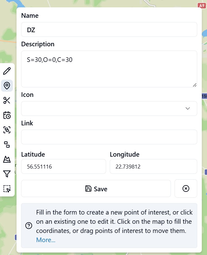
Supported waypoint names: WPE, WPN, WPM, WPS, WPC, WPP, PC, CP, CHECKPOINT, STOP, WPV, DSS, ASS, DZ, FZ, DN, FN, DT, FT. Unknown waypoints will be converted to WPE.
Use description field to set these as needed, seperated by comma:
S = speed (in km/h)
O = open (in meters)
C = clear (in meters)
P.S. In gpx.studio waypoint creation order is important because the exported file will
contain
waypoints in the order you added them. Start by adding the first waypoint, then the second,
etc. It is recommended to use a real and final recorded GPX track to add waypoints exactly on
the track line in sequential
order to get the best results.
How to add waypoints using ZINC navigator?
- Supported waypoint names: WPE, WPN, WPM, WPS, WPC, WPP, PC, CP, CHECKPOINT, STOP, WPV, DSS, ASS, DZ, FZ, DN, FN, DT, FT.
- Unknown waypoints will be converted to WPE.
- Waypoints without name will be ignored.
- Upload ZINC "route" file to the RoadbookRally.com
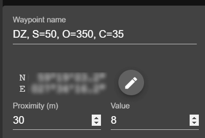
Use "waypoint name" field in ZINC to set these as needed, seperated by comma:
S = speed (in km/h)
O = open (in meters)
C = clear (in meters)
The first item before the comma must be a waypoint name (see screenshot below). If only a waypoint name is provided, default properties will be set for the waypoint. The 'Proximity' field is utilized as a 'clear' radius if no 'C=' is found in the name field.
The open radius will be equal to the clear radius if not defined in the 'waypoint name' field.
Beta
About BETA
RoadbookRally.com is fully operational and proven in live rally events worldwide.
The BETA label simply indicates that new management features are still being refined and released - not that the system is unstable.
Latest updates → 16 Oct 2026