FAQ
Frequently Asked Questions
RBR Roadbook Reader App
- How to scroll the roadbook?
- What is the "Autoscroll"?
- How to adjust/reset the odometer?
- Roadbook "countdown style"?
- Roadbook tulip/notes zoom (magnifier)
- How to lock screen roatation/touch?
- How to adjust the tripmeter?
- Speed limit zones, speeding
- What to do if lost (using go-to-note)?
- Miss or skip a waypoint
- Waypoints
- Auto-adjust Odometer
- Sounds
- About GPS: precise, fast, external?
- Using the RBR app offline
- Results or replay not showing up
- Device swapping during a ride
Riding roadbooks and GPX trails
Participate in the Event
Managing Tracks/Roadbooks
- How to create your first Digital Rally Roadbook?
- What should be considered when designing track/roadbook?
- How do I add/upload a track (Roadbook or GPX trail)?
- Can I edit and re-upload a roadbook? Will results recalculate?
- How do I export a roadbook from Rally Navigator?
- How to share tracks?
- How does "Navigate by" work?
- What is a Track/Roadbook PIN code?
- Access: Public, unlisted, private Track/roadbook visibility?
- Track structure errors
Organizing Events
- Can I use RBR as the event platform for my own rally business or club?
- How do I organize my first event?
- How do the payments and entry fees work?
- Event itinerary: classes, sections (tracks) explained
- Why can’t I change a competitor’s class after they’ve started riding?
- What is a Selective Section (SS)?
- What is a Rolling Start?
- How can competitors register for an event?
- How and when can competitors access event roadbooks?
- Event Track "visibility" (access) explained
- How to test-ride event tracks and itinerary?
- Nominal Time configuration
- What should be considered when choosing time zones for an event?
- Types of waypoints
- Auto-skipping missed waypoints
- Does the platform validate waypoints?
- What is a prologue?
- What is a Liaison or Road Section?
- Neutralization vs Transfer Zones (and refuelling)
- How to add a DN (neutralization zone)?
- How to set speed limits?
- Speeding penalties
- How do I set the DSS (section) start times?
- How do I record the start time as there will be no referee at the start?
- Start list live fullscreen mode
- Live Tracking
- Event "visibility" explained
- FIM & FIA regulations & Lexicon
How to ride and read the roadbook
Other
What should be considered when designing track/roadbook?
Updated
Including waypoints and speed zones in the track/roadbook is recommended to have
the full Rally Raid experience with the navigation app, but it is optional.
RoadbookRally.com and RBR Roadbook Reader app is designed to be aware of
these elements in the track.
Please be mindful of the following guidelines (don't worry, our track validator will warn you about any errors):
Please be mindful of the following guidelines (don't worry, our track validator will warn you about any errors):
-
Track analysis on RoadbookRally.com
It's important to note that the system records and analyzes rider data, including speed, speeding events, GPS, and replay data, only within the segment defined by the first and last waypoints of the track. Data outside this range is not included in the analysis.
It is considered good practice to place the first waypoint a few hundred meters after the start of the track to avoid accidental waypoint validations that might occur right at the start (e.g., while the rider is getting ready).
If the event section start type is standing start and the start is given by the start judge at the DSS, you can place the DSS anywhere, as accidental waypoint validations are not possible during standing starts.
The last waypoint, regardless of type, should be positioned at the very end of the track to ensure complete coverage of the route. But it is not mandatory. -
Exactly one Selective Section (SS) is allowed per
track/roadbook file
If you require more than one Selective Section (SS), kindly split your roadbook into two separate roadbook files and create two tracks/sections.
-
Exactly one start (DSS) and one finish (ASS) waypoint per
track/roadbook file
DSS (Start Selective Section): ASS (Finish Selective Section):
 *Make sure to add these locations as waypoints, not just as images. RBR will not recognize plain images.
 -
Track/roadbook should not start with a waypoint
This rule defines the minimum distance between the start of the roadbook/track (the first tulip) and the first waypoint of any type.
The track/roadbook must not start directly on top of a waypoint.
The start area should be placed at least:
100m + waypoint validation radius (usually around 90m) before the first waypoint.
Since the waypoint validation radius is commonly around 90m, the first waypoint should typically be placed at least ~190m after the start of the roadbook/track.
Reason: this helps prevent false-positive waypoint validations caused by riders waiting near the start area before actually starting the stage, while the app is already open and tracking. -
Track/roadbook must not end with a special STOP sign
Reason: To allow the system to validate whether the rider stopped at the STOP sign, the sign must not be placed at the last waypoint. Instead, the standard STOP traffic sign is better suited at the end of the roadbook.
The system is using this special STOP sign to analyze whether riders actually stop:
-
Waypoint Open radius
To avoid the waypoint opening before it is intended, it is important to ensure that the open radius is correctly sized. For example, if the waypoint intersects another part of the track where the rider will pass, the open radius should be adjusted accordingly to avoid mistakenly opening the waypoint.
Riders have the option to skip a waypoint or to open the previous or next waypoint using the W- and W+ buttons, respectively. However, by doing so, they will incur a penalty.
-
Waypoint Validation (clear) radius
Waypoint validation radii can overlap if the overlapping waypoints are not consecutive. In other words, if there is at least one other waypoint between the two overlapping waypoints, then the overlap is allowed. Do not worry, our track validator will warn you if there is a problem with overlapping waypoints!
Waypoints must be validated/cleared in a sequential order.
Take into account the rider's speed when they approach the validation/clear radius of the waypoint. If the radius is too small and the speed is too high, the rider may pass by it without the GPS device recording its position.
Validation radius above 20m is recommended, taking into account factors such as weather, terrain, and obstacles like mountains or buildings. The GPS typically updates once per second.
Consider higher validation radius values (100-200m) for open terrain when riders will be traveling at high speeds.
Riders' tripmeters will be recalibrated automatically on waypoint validation. -
Missed Waypoint Validation
The app uses an intelligent validation system that determines whether you may have missed a waypoint based on your physical proximity to it and your overall progress along the route. This prevents false missed waypoint alerts in situations where you accidentally or intentionally (e.g. laps) pass or validate upcoming waypoints that are too far along the route and not yet validatable according to the route logic. -
Speed Zones
- All speed limit zones must start with a DZ waypoint and end with an FZ waypoint.
- When using a speed zone (DZ waypoint), include the appropriate speed icon to indicate the speed limit.
- The speed limit within a speed zone can be adjusted by adding another DZ waypoint with a new speed icon. This allows the creation of a new speed zone without closing the previous one (DZ > DZ > FZ).
- Exercise caution when setting the Open and Clear/Validation radius for DZ and FZ waypoints. Ensure they are positioned to avoid intersections with other track areas and minimize the risk of accidental validation.
- Learn more: How to set speed limits?
-
Additional info for each track type:
-
Roadbook:
The RoadbookRally.com platform only supports the "OpenRally GPX" digital roadbook format (exported from the RallyNavigator.com) and does not accept PDF files.
- GPX Trail:
Navigation by GPX trail in RoadbookRally works the same way as navigation by roadbook. The only difference is that instead of showing the roadbook instructions, the RBR app displays the route line with waypoints on the map. The same rules apply as for a roadbook — DSS, ASS, speed zones, waypoint validation, etc.
This mode for the roadbook can be enabled by setting the Navigate by to GPX trail.
Requirements for GPX navigation- Simple GPX files contain only track points and are not valid for navigation.
- OpenRallyGPX includes all the metadata (waypoints, DSS, ASS, speed zones, etc.) that the RBR system requires.
- File type: Upload an OpenRallyGPX file, not a Simple GPX.
P.S. The RoadbookRally.com system will automatically generate waypoints for you if no waypoints found in the uploaded file. It is recommended to use use tools like Rally Navigator, ridewithgps.com or gpx.studio to set speed zones and waypoints for your GPX trace files.
With RallyNavigator, you can mark hazards (danger exclamation marks) in the roadbook, and they will be visible on the GPX map for the riders, like this: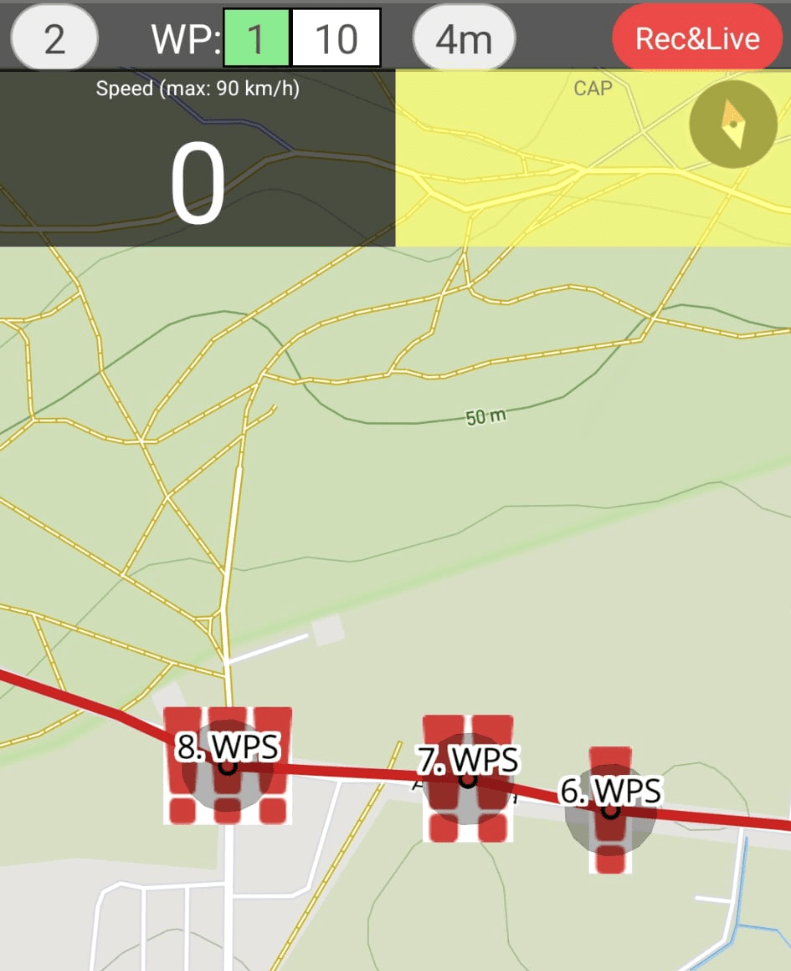 Drop us an email if you want RoadbookRally to add support for additional third
party GPX
management tool.
Drop us an email if you want RoadbookRally to add support for additional third
party GPX
management tool.
Recommended workflow- Create a standard roadbook first (with DSS, ASS, waypoints, speed zones).
- Export it as an OpenRallyGPX (if using RallyNavigator.com)
- Upload it to RoadbookRally and select Navigate this Track by → GPX trail.
- Verify that waypoints, DSS, ASS, and speed zones are visible on the GPX map.
How to add waypoints using gpx.studio or ridewithgps.com?
Supported waypoint names: WPE, WPN, WPM, WPS, WPC, WPP, PC, CP, CHECKPOINT, STOP, WPV, DSS, ASS, DZ, FZ, DN, FN, DT, FT. Unknown waypoints will be converted to WPE.
Use description field to set these as needed, seperated by comma:
S = speed (in km/h)
O = open (in meters)
C = clear (in meters)
brP.S. In gpx.studio waypoint creation order is important because the exported file will contain waypoints in the order you added them. Start by adding the first waypoint, then the second, etc. It is recommended to use a real and final recorded GPX track to add waypoints exactly on the track line in sequential order to get the best results.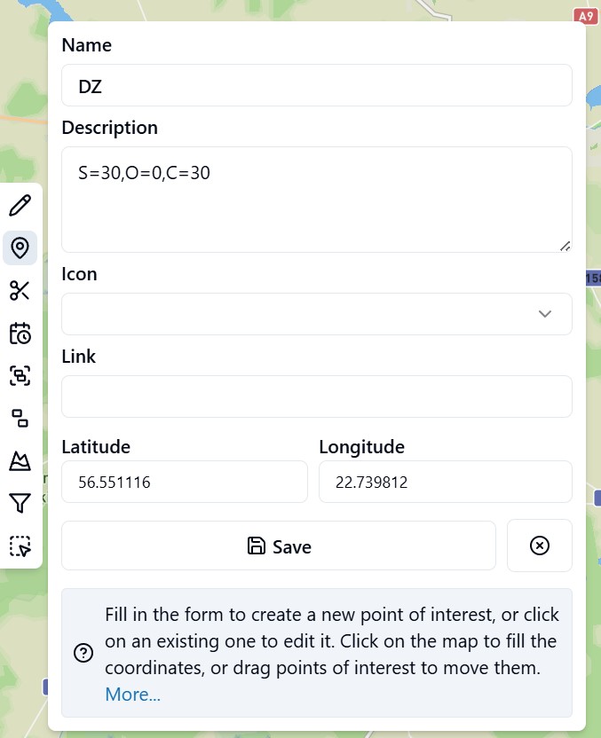
How to add waypoints using ZINC navigator?
- Supported waypoint names: WPE, WPN, WPM, WPS, WPC, WPP, PC, CP, CHECKPOINT, STOP, WPV, DSS, ASS, DZ, FZ, DN, FN, DT, FT.
- Unknown waypoints will be converted to WPE.
- Waypoints without name will be ignored.
- Upload ZINC "route" file to the RoadbookRally.com
Use "waypoint name" field in ZINC to set these as needed, seperated by comma:
S = speed (in km/h)
O = open (in meters)
C = clear (in meters)
The first item before the comma must be a waypoint name (see screenshot below). If only a waypoint name is provided, default properties will be set for the waypoint. The 'Proximity' field is utilized as a 'clear' radius if no 'C=' is found in the name field.
The open radius will be equal to the clear radius if not defined in the 'waypoint name' field.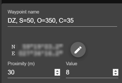
-
Roadbook:
Beta
About BETA
RoadbookRally.com is fully operational and proven in live rally events worldwide.
The BETA label simply indicates that new management features are still being refined and released - not that the system is unstable.
Latest updates → 18 Jul 2026
